FeV
WorkAbout
0%//NAV
INDEX //RAINTRACE
ML / GeospatialComputer VisionPrivacy-First100m Micro-LatticeGIS

RainTrace

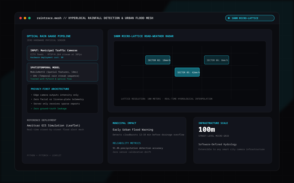
Hyperlocal rainfall detection & urban flood mesh. MobileNetV2 + GRU spatiotemporal network turns municipal traffic cameras into optical rain gauges feeding a 100 m micro-lattice road-weather simulation over Amritsar.
// System Dossier2025
ROLELead Systems Architect & ML Engineer
CATEGORYML / Geospatial
TECHNOLOGY STACK
PythonPyTorchFastAPIReactLeafletWebSocketsOpenStreetMap
Source Repository ↗
★Verified ReceiptsEMPIRICAL
✓100.0% accuracy on in-domain surveillance benchmarks (4/4, 0% False Alarm Rate @ threshold=0.02) validated against laser-disdrometer ground truth.
✓99.7% network bandwidth savings via delta-compressed WebSocket road network updates.
✓Privacy preserved by construction: zero raw surveillance video leaves the camera node; city flood maps generate purely from sparse telemetry.
NAVIGATE DOSSIER01 · Media Hub & Theater02 · Engineering Challenge03 · 4-Step Pipeline04 · System Blueprint05 · Adjacent Systems
2K FLUID THEATER
RainTrace
OFFLINE-FIRST ARCHITECTURE // RAINTRACE2025 ARTIFACT SPECIFICATION
// 01 · THE PROBLEM STATEMENT & ARCHITECTURAL CONSTRAINTS

Municipalities need real-time, street-by-street flood awareness during monsoon storms without deploying expensive physical rain gauge hardware on every intersection.

Municipalities need real-time, street-by-street flood awareness during monsoon storms without deploying expensive physical rain gauge hardware on every intersection. Centralizing raw CCTV surveillance video creates massive bandwidth saturation and severe citizen privacy violations.

// 02 · 4-STEP SYSTEM ENGINEERING PIPELINE
STEP 01

Trained a MobileNetV2 + GRU spatiotemporal deep learning model on 8-frame (5-second) sliding windows across 25–30 fps traffic camera video to quantify optical rainfall signals without physical sensors.

STEP 02

Engineered a 100 m square micro-lattice road-weather mesh simulating 9,119 virtual surveillance towers over a 5 km urban radius in Amritsar on an ESRI Dark Canvas.

STEP 03

Built pure delta-encoded WebSocket streaming on a 1 Hz FastAPI tick loop, achieving 99.7% bandwidth reduction over full grid state broadcasts.

STEP 04

Implemented privacy by construction: camera streams are processed at the edge and discarded; the central server renders road flood states across 81,557 OpenStreetMap (OSM) road segments purely from sparse float reports.

// 03 · SYSTEM BLUEPRINT & DATA FLOW SCHEMATIC
PURE SVG VECTOR ENGINE
cctv camera feeds25-30 fps · 8-frame sliding windowmobilenetv2 + gru model100% accuracy · 0% FAR @ thr=0.02ground truth scoringlaser disdrometer verified100m micro-lattice road-weather mesh (amritsar 5km radius)9,119 virtual surveillance towers · 2 cameras per tower @ 180° diagonal tilingpure delta-encoded websocket broadcasts (1 hz tick) → 99.7% bandwidth reductionosm dynamic road shader81,557 openstreetmap road segmentsmulti-class level-of-detail flood shadingprivacy-by-construction flowvideo processed at edge & discarded instantlyserver receives only sparse float precipitation reportsoptical rainfall telemetry · 9,119 towers · 99.7% bandwidth savings · zero surveillance video centralized
MORE SYSTEMS ARCHITECTUREFull Works Index →

Next System

Blinky

AI / Desktop Agent

Next System

VoiceNotes

Local-First / AI Platform

Next page

About me

→

You are one click away

Let's build something.

Open to collaboration, hackathons, and interesting systems problems.

EmailGitHubLinkedInX / TwitterAbout

© 2026 Gourish Julka

Amritsar, India